Weather Satellites and their SARSAT Technology Saved Hundreds … – Weatherboy
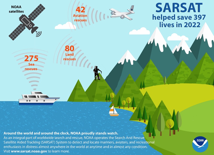
While NOAA’s fleet of weather satellites provide huge volumes of data and imagery to help meteorologists forecast weather and warn people of upcoming storms, the satellites also save lives through their SARSAT technology. According to NOAA, 397 people were rescued around the U.S. from this satellite-based technology.
Short for “Search and Rescue Satellite Aided Tracking system”, SARSAT uses a network of U.S. spacecraft to detect and locate distress signals sent from emergency beacons from aircraft, boats, and handheld Personal Locator Beacons (PLBs). A similar system, COSPAS, was developed by the Soviet Union. The four nations, United States, Canada, France and the Soviet Union banded together in 1979 to form COSPAS-SARSAT which helps locate people in distress around the globe.
The beginnings of SARSAT date back to October 1972 when a plane carrying two U.S. congressmen, Representatives Hale Boggs (D-Louisiana) and House Majority Leader and Representative Nick Begich (D-Alaska), went missing in a remote region of Alaska. A massive search and rescue effort was mounted, but to this day, no trace of them or their aircraft has been found. In reaction to this tragedy, Congress mandated that all aircraft in the United States carry an Emergency Locator Transmitter (ELT). This device was designed to automatically activate after a crash and transmit a homing signal. ELT analog technology had been developed and available since the 1950s. The original system was designed to automatically transmit a homing signal whenever a plane crashed.
As the 1960s transitioned to the 1970s, there were significant advances in space technology and space-based applications. Space technology applications opened up using satellites to address weather communications as well as navigation. Within NASA, it was recognized that another benefit of satellite technology could be search and rescue. It was thought that if overflying aircraft within limited range of a downed aircraft could pick up an activated beacon signal, an overflying satellite could pick up a beacon’s signal from a much greater region.
The SARSAT system was developed in a joint effort by three countries that were all looking at space as a solution for improvements in search and rescue. The United States, Canada and France worked together to develop the space, ground and beacon technology needed for the system to work. In the United States, NASA took the lead. In the United States NOAA, NASA, the U.S. Coast Guard, and the USAF, partnered to form the U.S. SARSAT Program.
Once the system was functional, its operation was turned over to NOAA where it remains today. As the system began to take hold, more and more emergency beacons found their way onto the market. The U.S. Coast Guard in their role as maritime search and rescue specialists immediately saw the benefits of 406 MHz, and in 1990, took proactive steps to bring it into widespread usage. As a result, today there are over 723,000 emergency beacons registered in the NOAA 406 MHz Registration Database.
Of the 397 U.S. rescues last year, 275 were water rescues, 42 were from downed aircraft and 80 were on land involving PLBs. Florida had the most SARSAT rescues with 106, followed by Alaska with 56 and Utah with 20.
“The value of NOAA satellites goes well beyond forecasting,” said Steve Volz, Ph.D., assistant administrator for NOAA’s Satellite and Information Service. “The life-saving ability of SARSAT is a credit to the teamwork with the U.S. Coast Guard, the U.S. Air Force NASA and our international partners.”
While the hundreds of rescues were remarkable, three events in 2022 really demonstrated the system’s benefits.
On June 10, a group of 17 hikers were hoisted to safety after they were stranded on a ridge in Sandthrax Canyon, Utah. The Air Force Rescue Coordination Center received the alert from a PLB and notified the Garfield County Sheriff’s Office, which launched a Utah Department of Public Safety helicopter to the coordinates where the distressed hikers were located.
On November 20, seven people were rescued from a commercial plane after it was forced to land on a frozen lake near Bethel, Alaska, as a result of engine failure. The Alaska Rescue Coordination Center, which obtained the coordinates of the downed plane, alerted another aircraft company, which made the rescue.
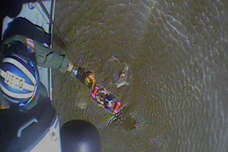
On August 5, a U.S. Coast Guard helicopter pulled a sailor to safety from his capsized boat off the coast of New Smyrna Beach, Florida. The sailor grabbed the life raft and activated his beacon before his boat sank.